---
title: "Seceda Ridgeline"
type: "1day-itinerary"
lang: "en"
distance_km: 4
elevation_plus_m: 260
elevation_minus_m: 270
difficulty: "Medium"
duration_days: 1
url: "https://dolomites-guide.com/hiking-dolomites/seceda-ridgeline/"
description: "Complete guide to the Seceda ridgeline hike above Ortisei. Two loop options, gondola logistics, Troier Hut, Pic da Cristauta, and trail conditions."
---
# Seceda Ridgeline
Walk the most iconic ridgeline in the Dolomites, tracing the spine of the Odle massif above Val Gardena. Choose between a short summit loop from the gondola ({{4 km | 2.5 mi}}) or a full-day circuit via Monte Pic da Cristauta ({{13.1 km | 8.1 mi}}), both with continuous views of the Geisler spires.
## Overview
The Seceda Ridgeline is the most photogenic ridge walk in the Dolomites, tracing the spine of the Odle (Geisler) massif above Val Gardena. From the top station of the Seceda gondola at 2,518 m (8,261 ft), a short summit loop covers 4 km (2.5 mi) with 260 m (853 ft) of climbing - a compact 1.5-hour circuit past the Seceda summit, Troier Hut, and Mastlé Alpine Hut that delivers one of the most iconic landscapes in the Alps. A longer 13.1 km (8.1 mi) full-day loop starting from the valley adds Monte Pic da Cristauta and two more mountain huts.
## Stats
- Distance: 4 km
- Elevation gain: 260 m
- Elevation loss: 270 m
- Difficulty: Medium
- Duration: 1 day
## Need to know
## Where is the Seceda Ridgeline?
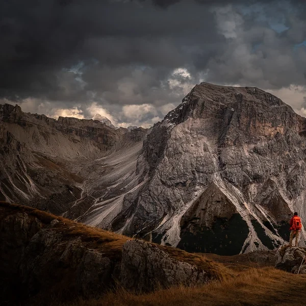
The Seceda (2,519 m (8,264 ft)) sits at the western edge of the **Puez-Odle Nature Park** (Naturpark Puez-Geisler), directly above **Ortisei (St. Ulrich)** in Val Gardena (Grödnertal). The ridgeline runs east-west along the northern rim of the Odle/Geisler group - a wall of fractured dolomite spires that rise like broken teeth from the green valley floor below. The classic photograph everyone recognizes is taken from the ridge looking south-southeast toward the Odle pinnacles, with the emerald pastures of Val Gardena sweeping away beneath them.
Two loop options start from this area. The short summit loop begins at the gondola top station and circles the Seceda peak via **Troier Hut** and **Mastlé Alpine Hut**. The full-day loop starts from the valley parking and adds **Gamsblut Hut**, **Monte Pic da Cristauta (Pitschberg)**, and **Seurasas Hut** for a complete tour of the massif. For orientation, the ridge runs roughly parallel to the valley, with **Santa Cristina (St. Christina)** directly below to the south and the sheer north face dropping into the remote **Villnöss (Funes)** valley.
## Which Route Option is Best for You?
The Seceda ridgeline can be experienced as a short summit loop from the gondola top station or extended into a full-day circuit starting from the valley. The two options deliver very different experiences in terms of effort, duration, and the number of huts you pass along the way.
### Option #1: The Summit Loop (The Classic)
* **Who is it for?** Hikers who want the iconic views without committing to a full day. Ideal for families with older children (10+) and photographers.
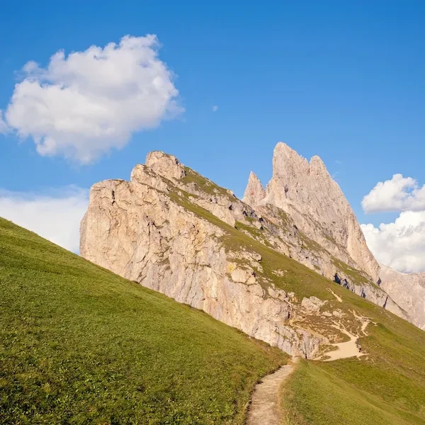
* **The Route:** From the Seceda gondola top station, head west to the **Seceda Summit** for the famous panorama of the Odle spires. The trail then loops east, descending to **Troier Hut (Malga Troier)** - a beautiful alpine hut and ideal stopover on the way. From Troier, continue south to **Mastlé Alpine Hut** before climbing back to the gondola station, completing the circuit.
* **Distance:** 4 km (2.5 mi) loop
* **Elevation:** 260 m (853 ft) ascent, 270 m (886 ft) descent
* **Time:** 1.5 to 2 hours including a stop at Troier or Mastlé.
* **Difficulty:** Moderate. Well-marked trails on alpine terrain. No technical sections, but the paths around the summit are exposed and can be slippery when wet.
* **The Reality:** This is a compact loop that packs in the best of Seceda without the commitment. The summit viewpoint delivers the "money shot" of the Odle pinnacles. The descent to Troier Hut is on good trail, and both Troier and Mastlé offer food and drinks with spectacular terrace views. Poles are helpful but not essential on this shorter circuit.
### Option #2: The Full Loop via Monte Pic da Cristauta
* **Who is it for?** Strong hikers who want to make a full day of it and see the Odle group from every angle, passing through five mountain huts along the way.
* **The Route:** This loop starts and ends at the **valley parking area** below the gondola, making it a true hiking day without relying on the cable car. From the parking, climb south through forest to **Gamsblut Hut** - a quaint, less-crowded alternative to the busier huts higher up. Continue ascending to **Troier Hut**, then push north to the **Seceda Summit** for the iconic ridge panorama. From the summit, the trail heads west along the ridge before turning south toward **Monte Pic da Cristauta (Pitschberg)**, a beautiful secondary summit. The descent continues to **Seurasas Hut** (2,176 m (7,139 ft)) with its fantastic views, before the final steep drop back to the valley parking.
* **Distance:** 13.1 km (8.1 mi)
* **Elevation:** 930 m (3,051 ft) ascent and descent
* **Time:** 5 to 6 hours.
* **Difficulty:** Hard. The total elevation gain is significant, and the route crosses exposed alpine terrain at altitude. Good fitness required.
* **The Reality:** This is the full Seceda experience - valley to summit and back under your own power. The climb to Gamsblut and Troier is steady but relentless. The reward is earning the summit views rather than stepping off a gondola. The section over Pitschberg adds a second summit that most Seceda visitors never see. By mid-afternoon in summer, thunderstorms build over the Odle peaks with little warning. Start early and be descending by 14:00. Poles are strongly recommended for the steep final descent.
## How Do You Reach the Seceda Gondola?
The Seceda gondola (Seceda Bergbahn) departs from the center of **Ortisei (St. Ulrich)**, the main town of Val Gardena. The base station is located on Via Setil, a 5-minute walk from the main square.
### Reaching Ortisei
- **By Car:** From the **A22 Brenner motorway**, exit at **Chiusa (Klausen)** and follow the SS242 into Val Gardena. Ortisei is the first major town, approximately 15 minutes from the motorway exit. From **Bolzano**, the drive is 40 minutes.
- **Parking in Ortisei:** The town center has limited street parking. Use the **underground garage at Piazza Stazione** (approx. 8 EUR ($9)/day) or the free parking lots on the eastern edge of town. In July and August, arrive before 08:30 or the garage fills up.
- **By Bus:** The **Val Gardena Express** (Line 351) connects the valley to **Bolzano** and **Bressanone (Brixen)**. Buses run every 20-30 minutes in summer. The Südtirol Guest Card (provided free by most hotels) covers all public transport, including this line.
### The Seceda Gondola
- **Operating Season:** Typically mid-June to mid-October and mid-December to mid-April (winter skiing).
- **Summer Hours:** First ascent usually at **08:30**, last descent at **17:00** (verify on funivieortisei.it as hours shift by week).
- **Return Ticket:** Approximately **27 EUR ($30) for adults** (verify current rates on funivieortisei.it - prices adjust annually). The Val Gardena Active Card, included with most hotel stays of 3+ nights, covers the Seceda gondola and dozens of other lifts. If you are staying in the valley for more than a day, this card alone justifies the hotel price.
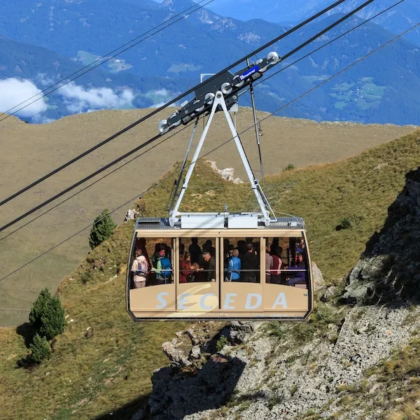
- **The Gondola Itself:** Two-stage system. Stage 1 rises to **Furnes** (mid-station at 1,356 m (4,449 ft)). Stage 2 continues to the **summit at 2,518 m (8,261 ft)**. Total ride time: approximately 15 minutes. On clear summer mornings, expect a 20-40 minute queue for Stage 2.
## When Should You Visit & How to Check Conditions?
### The Best Season
The hiking window on Seceda runs from **mid-June to mid-October**, dictated by snowmelt on the ridge and gondola operating dates.
- **Mid-June to Early July:** The ridge may still hold snow patches on the north-facing traverse. Check conditions with the Ortisei tourist office before committing. The wildflowers on the southern meadows, however, are at their absolute peak - fields of gentian, arnica, and alpine roses carpet the slopes around Troier and Mastlé.
- **July to August:** Prime season. The ridge is fully clear. However, afternoon thunderstorms are a near-daily occurrence from 14:00 onward. The Odle peaks act as a lightning magnet. Start with the first gondola and be off the ridge by early afternoon.
- **September to Mid-October:** The golden window. Larch forests turn deep amber, the air is crystalline, and the summer crowds vanish. Temperatures drop sharply - expect 0-8°C (32-46°F) on the ridge at sunrise. The trade-off: shorter days and earlier gondola closures.
### The Lighting Strategy
The Odle spires face roughly south-southwest. In the morning, they catch direct sunlight and glow warm orange against a deep blue sky - this is when the "money shot" from the ridge is at its best. By afternoon, the light flattens and the peaks fall into shadow. Photographers should take the **first gondola** and shoot within the first two hours.
### How to Check the Weather
Generic weather apps pull data from the valley floor at 1,200 m (3,937 ft) - completely useless for a ridge at 2,500 m (8,202 ft) where conditions are 10-15°C (18-27°F) colder with triple the wind. Use **Meteoblue**, the only model that accurately predicts cloud ceilings and wind at altitude. The live forecast below is tuned to Seceda summit elevation.
## What Essentials Must Be in Your Pack?
The Seceda ridge sits above 2,400 m (7,874 ft) with zero shelter from wind or sun. The exposed crest amplifies both hazards - the pale dolomite reflects UV from below while the north face funnels wind directly into your path. Do not let the easy gondola access fool you into treating this as a park walk.
### Footwear
- **The Path:** The ridge trail is compacted gravel with exposed sections near the summit. The descent toward Troier Hut and the steeper sections on the full loop require secure footing on uneven alpine terrain.
- **The Recommendation:** Approach shoes with a Vibram sole or sturdy trail runners are the minimum. Lightweight hiking boots are ideal if you plan the full loop. Standard sneakers or sandals (yes, people try) will slide on the scree descent and offer zero ankle protection.
- **Poles:** Strongly recommended for the full loop (930 m (3,051 ft) of elevation change). Helpful but not essential on the shorter summit circuit.
### Sun & Skin Protection
- **The Exposure:** At 2,500 m (8,202 ft), UV intensity is roughly 30% higher than sea level. The pale limestone doubles this through reflection. You will burn on cloudy days.
- **Sunscreen:** Apply SPF 50+ before boarding the gondola. Reapply after 2 hours. The wind evaporates sweat, masking the heat while your skin cooks.
- **Eyes:** Category 3 or 4 sunglasses are mandatory, not optional. Snow glare in early season and rock glare in high summer cause lasting eye fatigue.
### Clothing Strategy
- **The Ridge Wind:** The Seceda crest acts as a wind tunnel between Val Gardena and Villnöss. Even on a calm valley day, expect sustained 20-30 km/h (12-19 mph) winds on the ridge, with gusts significantly higher. Windchill can drop the perceived temperature by 10°C (18°F).
- **The Layering System:** Synthetic or merino base layer (never cotton). A fleece mid-layer for warmth during stops. A **wind-shell or hardshell jacket** is non-negotiable - pack it even on a blue-sky day. In June, September, and October, add gloves and a beanie.
### Hydration & Logistics
- **Water:** Carry at least 1.5 l (50 fl oz) for the full loop (0.5 l (17 fl oz) is enough for the short summit circuit). Multiple huts along both routes sell drinks, but the dry altitude and wind dehydrate faster than you notice.
- **Cash:** Most huts accept cards, but terminals rely on mobile signal that fails regularly in poor weather. Carry **30-40 EUR ($33-$44) in small bills and coins** as backup. The 1 EUR ($1) coins are needed for the WC at the gondola top station.
## Dining on the Route
Both loop options pass through mountain huts that serve far more than just drinks. **Troier Hut (Malga Troier)** sits on both routes and is the natural lunch stop - a beautiful alpine hut with a sun-drenched terrace and panoramic views of the Odle spires. On the short loop, **Mastlé Alpine Hut** offers a quieter alternative with equally friendly service. On the full loop, **Gamsblut Hut** is a quaint, less-crowded option on the initial climb, and **Seurasas Hut** at 2,176 m (7,139 ft) rewards the final descent with a fantastic panorama. All huts are open **mid-June to mid-October**, weather permitting.
### What to Order
- **Kaiserschmarrn:** The signature dish of every South Tyrolean hut. A thick shredded pancake caramelized in butter, served with wild cranberry compote and dusted with powdered sugar. The best versions use local eggs and are cooked to order - expect a 15-minute wait, which is the sign of the real thing. (12-14 EUR ($13-$15))
- **Schlutzkrapfen:** Half-moon dumplings filled with spinach and ricotta, browned in sage butter. This is the Ladin staple - the valley's answer to ravioli. (13-16 EUR ($14-$18))
- **Speckknödel:** Bread dumplings studded with smoked South Tyrolean speck, served in a clear broth or with sauerkraut. Hearty fuel for the rest of the loop. (11-14 EUR ($12-$15))
- **Fresh Buttermilk:** Straight from the valley dairy cooperatives. Cold, tangy, and far more rehydrating than water after a ridge walk.
### The Timing Trap
Do not expect to walk into Troier Hut at 12:30 in August and find a table. The terrace fills by noon with hikers from both the summit loop and the full circuit. Arrive before 11:30 for a guaranteed seat, or plan lunch for after 14:00 when the day-trippers start their descent.
## The Geology Behind the View
The dramatic profile of the Odle spires that you see from the Seceda ridge is not erosion alone - it is the result of a **240-million-year collision** between ancient reef systems. The Odle group is composed of **Hauptdolomit** (main dolomite) - the calcium-magnesium carbonate that gives the Dolomites their name and their distinctive pale grey color. These peaks were once coral reefs in the warm Tethys Sea during the Triassic period. Tectonic uplift pushed them skyward, and ice-age glaciers carved the vertical faces you see today.
The green meadows of Val Gardena below are equally remarkable. What looks like "natural" pasture was actually **dense spruce forest** until roughly 800 years ago, when Ladin farming communities cleared it by hand for summer grazing. The neat patchwork of fields you see from the ridge is not wilderness - it is one of the oldest continuously managed cultural landscapes in the Alps.
## The Ladin Soul of Val Gardena
Val Gardena is one of only five valleys in the Dolomites where **Ladin** - a Rhaeto-Romance language predating both Italian and German - remains the first language of daily life. In Ortisei, shop signs are trilingual (Ladin, Italian, German), and the woodcarving tradition that made the valley famous dates back to the 17th century, when isolated winter months pushed farmers toward artistic craft.
At the mountain huts along the route, if you listen carefully, you will hear the staff speaking Ladin among themselves - a living link to a linguistic tradition older than most European nation-states.
## Practical info
- Best season: Mid-June to Mid-October
- Accommodation: Hotels in Ortisei, Santa Cristina, or Selva
- Navigation: Well-marked alpine trails
- Gear: Approach shoes or hiking boots, poles (full loop), wind shell, sun protection
- Start Point: Seceda Gondola Top Station (Option 1) or valley parking (Option 2)
- End Point: Same as start (both are loops)